UnPaved™ - 1.5 Million+ Miles of Off-Roads & Trails for the Western Hunter
The UnPaved™ offline map layer is ever-growing, both in total miles of off-roads and trails, as well as in the depth of data and detail in each mile. This is just the beginning of one of the most vital layers you’ll ever have as a western hunter, and it's only available in the Scout To Hunt app.
Accessing Your Public Land Hunts
Off-roads and trails are the circulatory system of public land, and of all the outdoorsmen, the western hunter knows how to make the most of it. Western hunters truly recognize the full value of a comprehensive off-roads and trails system as they incessantly search for the best path to success.
Scout To Hunt's UnPaved™ offline map layer was developed to simplify that search, tailored to the western hunter's demands.
It's not so much a matter of convenience, as it is a matter of advantage. Time and timing are everything when chasing very keen big game animals. Adequately preparing for and navigating new country or rough terrain will allow you to maximize your limited time and capitalize on the fleeting opportunities within it.
Seeing the (Off-)Roads Ahead
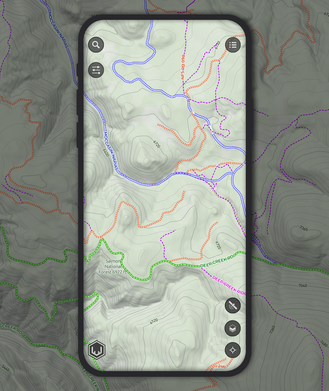
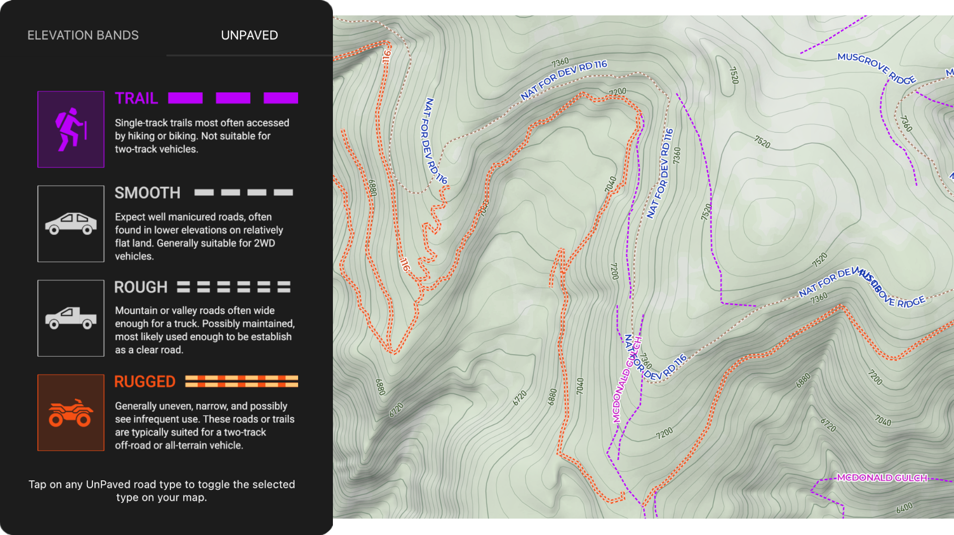
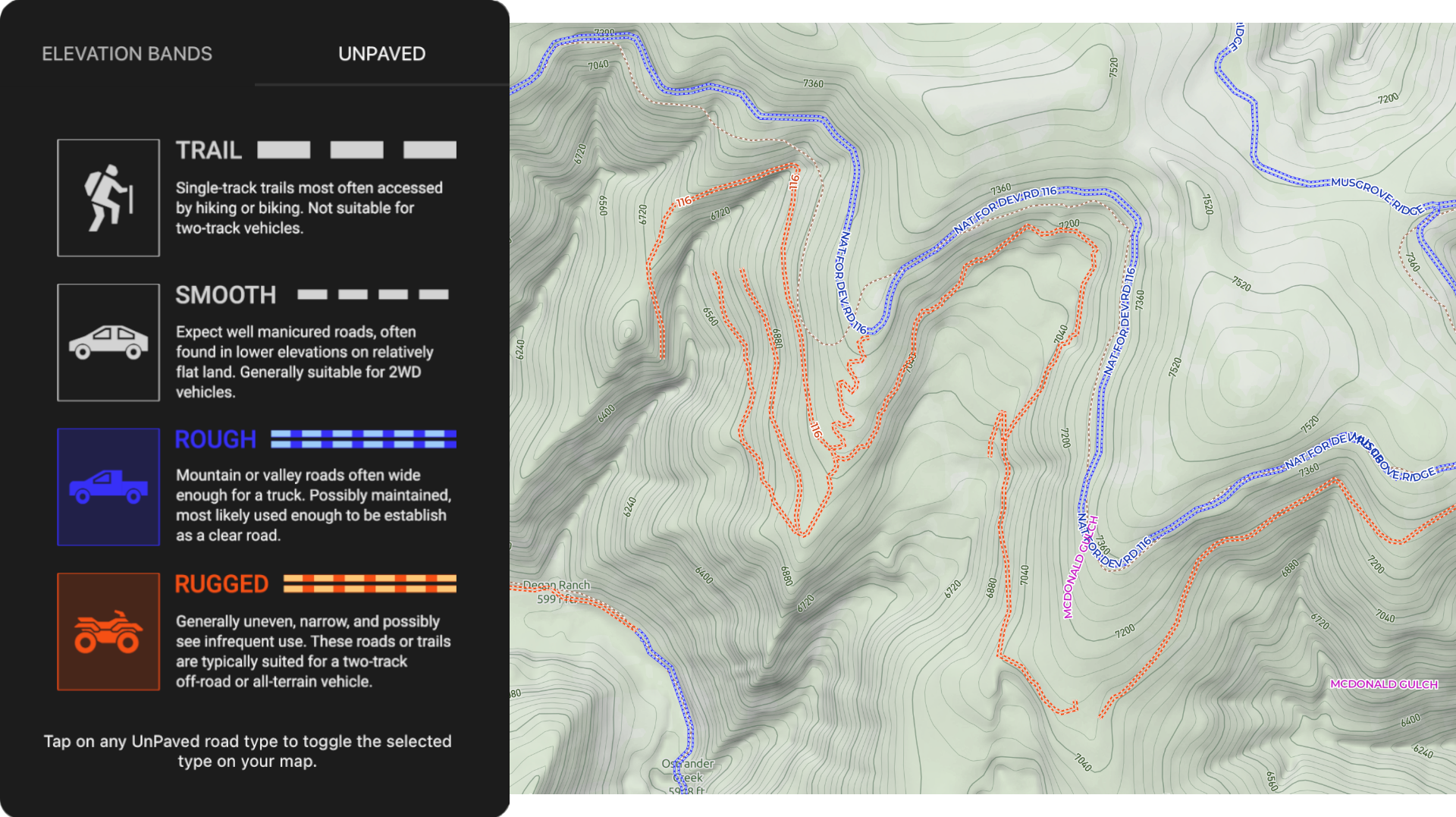
With the UnPaved™ offline map layer, you can position yourself for success even before you roll off the pavement, having gained the foresight of an efficient roadmap to your target hunt area by utilizing the four comprehensive off-road classes that cover your map.
With UnPaved™, you can better understand the terrain you expect to tread, so you can prepare and plan accordingly. Avoid exceeding vehicle capabilities and tolerances and the subsequent costs in time and money for repairs - and possibly even a depressing walk for help.
UnPaved™ should be leveraged during the early stages of your hunt planning. Determine the best routes along with the right expectations as you plan to access your targeted hunt area. Knowing where you need to be on your hunt is fundamental. Knowing how to get there is critical.
The Path of Least Resistance
With UnPaved™ you are in complete control of the 1.4 Million+ miles of western off-roads and trails. Select which off-road classes you need to see, and remove the ones you don't by toggling the four individual off-road types found in the Layer Adjustment menu.
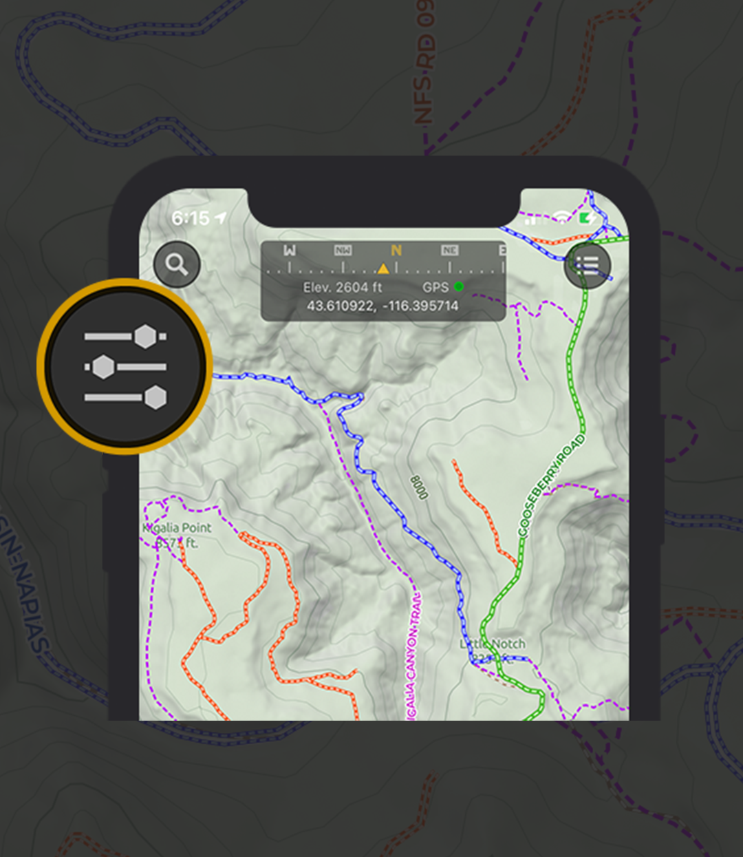
The Layer Adjustment button appears on the upper-left corner of your main map screen only when a modular layer, such as the Elevation Bands or UnPaved™ layers are toggled on. In the Layer Adjustment menu, you can see how each class is defined and select which class you need or do not need to see on your map.
This level of freedom and personalization provides you the flexibility you demand in order to see where or how far along on your designated route a certain vehicle type should most likely go.
This allows you to determine continuity in your planned routes when accounting for a vehicle's capacity and when and where you should plan to hop in a better suited vehicle, such as an ORV, or even by foot.
The purpose of a map is to help you navigate from point A to point B. Without Scout To Hunt's UnPaved™ layer the hunter's map is naked and incomplete.
With 1.4 million+ miles of off-roads and trails identified and organized into four comprehensive classes, the UnPaved™ offline map layer provides you the critical knowledge you require to determine your path to success.
Access new areas to hunt, broaden your landscape of opportunities, and confidently navigate through new country. Start planning new routes and discovering more off-roads with the UnPaved™ offline map layer in the free Scout To Hunt app:
Now available in 8 big game western states (AZ, CO, ID, MT, NM, NV, UT, WY).

The Power Couple
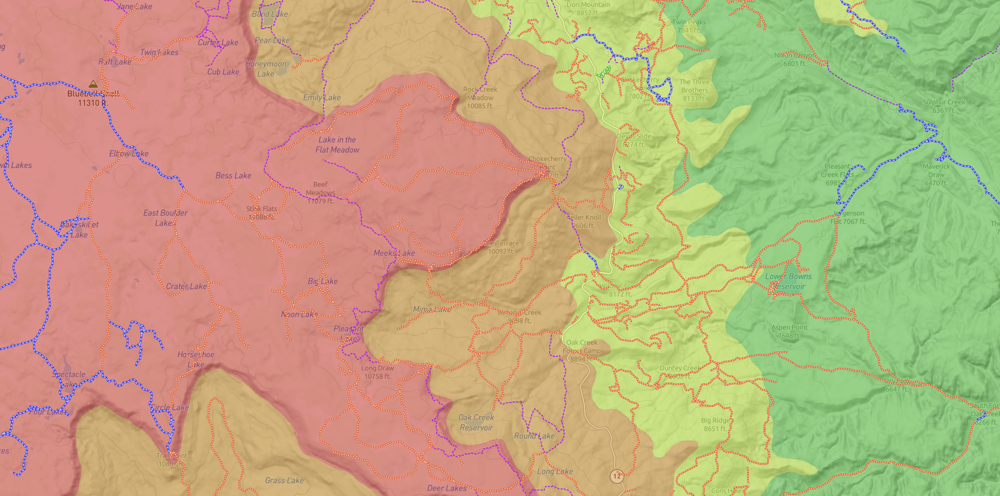
When UnPaved™ is used together with the Elevation Bands layer, your route planning will be elevated to new heights of success.
Not only do you have a clear view of the elevation ranges you expect to ascend, but a robust assessment of how to navigate through them. Observe the elevation ranges your route passes through and take note of the potentially varying road conditions you might use to access your target hunt area.
Find your path to success with Scout To Hunt's UnPaved™ - Comprehensive Off-Roads & Trails System